
Particularly Dangerous Situation (PDS) Information
Particularly Dangerous Situation (PDS)
A PDS is used by the Storm Prediction Center to describe an enhanced risk of severe and life-threatening weather conditions. PDS's are types of severe weather watches and are likely issued when a major severe weather outbreak is expected with tornadoes, derechos and other major severe weather threats. A PDS Watch (Tornado, Severe Thunderstorm, Flash Flood, etc) is likely in effect for an area at the same time an area is included in a moderate or high risk zone issued by the Storm Prediction Center. PDS Watches are rarely issued.
PDS Tornado Watch
A PDS Tornado Watch is issued when violent, intense, long living, and dangerous tornadoes are expected within the watch area. Tornadoes that occur within PDS Tornado Watch areas are likely to be scaled as EF4's or EF5's on the Enhanced Fujita Scale. (See image below.) A situation in which a PDS Tornado Watch is issued would be when a major tornado outbreak is likely within the watch area. When a PDS Tornado Watch is issued, persons need to remain alert and continuously monitor changing weather conditions. (See the Tornado Safety page for tornado safety information.)
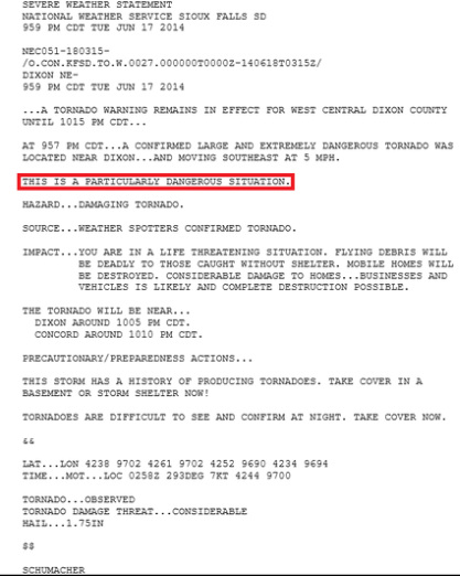
PDS Tornado Warnings may be issued, as well. These are very similar to Tornado Emergencies. (See the Weather Definitions page for more information on Tornado Emergencies.) The image below is an example of a PDS Tornado Warning issued for Dixon county in Nebraska.
A PDS is used by the Storm Prediction Center to describe an enhanced risk of severe and life-threatening weather conditions. PDS's are types of severe weather watches and are likely issued when a major severe weather outbreak is expected with tornadoes, derechos and other major severe weather threats. A PDS Watch (Tornado, Severe Thunderstorm, Flash Flood, etc) is likely in effect for an area at the same time an area is included in a moderate or high risk zone issued by the Storm Prediction Center. PDS Watches are rarely issued.
PDS Tornado Watch
A PDS Tornado Watch is issued when violent, intense, long living, and dangerous tornadoes are expected within the watch area. Tornadoes that occur within PDS Tornado Watch areas are likely to be scaled as EF4's or EF5's on the Enhanced Fujita Scale. (See image below.) A situation in which a PDS Tornado Watch is issued would be when a major tornado outbreak is likely within the watch area. When a PDS Tornado Watch is issued, persons need to remain alert and continuously monitor changing weather conditions. (See the Tornado Safety page for tornado safety information.)
PDS Tornado Warnings may be issued, as well. These are very similar to Tornado Emergencies. (See the Weather Definitions page for more information on Tornado Emergencies.) The image below is an example of a PDS Tornado Warning issued for Dixon county in Nebraska.
PDS Severe Thunderstorm Watch
A PDS Severe Thunderstorm Watch is issued when a major severe weather outbreak with severe thunderstorms containing very strong and damaging winds are expected. These storms may contain large and severe hail, as well. Thunderstorms that occur within PDS Severe Thunderstorm Watch areas may cause major damage to homes and buildings. Derechos will likely cause damage of this severity, such as the very destructive derecho that caused significant damage in the Ohio Valley and Mid-Atlantic regions on June 29, 2012. (See the Weather Definitions page for more information on derechos. Also, see the Derecho Climatology image below the Enhanced Fujita Scale image.) When a PDS Severe Thunderstorm Watch is issued, persons need to remain alert and continuously monitor changing weather conditions.
PDS Flash Flood Watch
PDS Flash Flood Watches are not issued by the Storm Prediction Center, but by National Weather Service offices. A PDS Flash Flood Watch is issued when there is abnormally high potential for life-threatening flooding. (See the Flood Safety page for flood safety information.)
Enhanced Fujita Scale
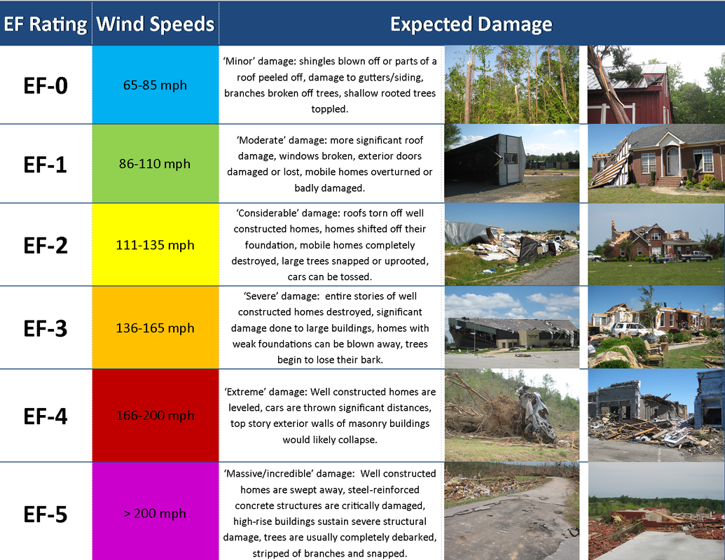
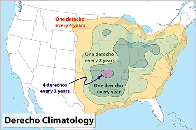
Image Sources: National Weather Service
© 2024 Central Ohio Weather Alerts
